
The hot towers of Crater Rock oozed gas and steam upwards into the clear blue sky. I lay in the warm sun below the Manzama Chutes admiring the scene briefly. I stood back up on my skis and proceeded to cut corn. Curving over the headwall I discovered the best steep turns ever. Rime towers on the right, the Zig Zag Glacier below and perfect snow made for an indelible memory.
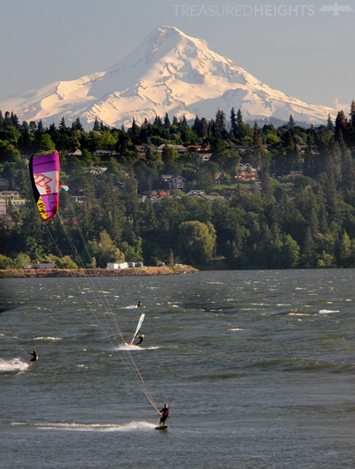
Mount Hood is an iconic sharp volcano close to Portland Oregon. Over 10,000 people attempt the mountain each year and for many it’s their first glaciated peak. An easy drive up to 6,000’ makes the mountain very accessible and attractive. The skiing is completely amazing when the conditions are good. Firm safe snow can allow for cutting turns on slopes steeper than 60 degrees. The peak is perfect for skiing as it has both gentle slopes and steep lines. Local skiers have explored and loved every face of this multi-faceted pyramid for a half century.
South Side Route
It was early June and there was plenty of snow around. The trailhead of the standard route up Hood starts off at the Timberline Lodge parking lot at 5900’. The massive lodge with luxury rooms serves the Timberline Ski Area. The ski area is North America’s only place where you can get lift serviced skiing year round, this makes it popular for summer ski training programs.
 I started in the wee hours of the morning, skinning up the groomed trails of the ski area. The first 2,600 feet of the peak is a slog up moderate slopes of the ski area and this part should be done in the dark. Don’t start too late in the morning, that leads to increased exposure to rockfall or nasty ice chunks when your near the top below crumbly lava cliffs.
The sun rose casting a beautiful triangular shadow on the clouds below. This part reminded me of my trips on Cotopaxi years ago. Triangular-shaped peaks have a unique feel and beautiful “math” as all routes dramatically culminate at the top.
I hit steeper and icy slopes and a rotten smell as the cone-shaped mountain increasingly got steeper. At this point I felt that skinning was no longer safe and it was time to walk up. If you are lucky and have the right conditions you can skin all the way up to the caldera. I threw on the crampons and bee-lined up through the stink.
The Devil’s Kitchen:
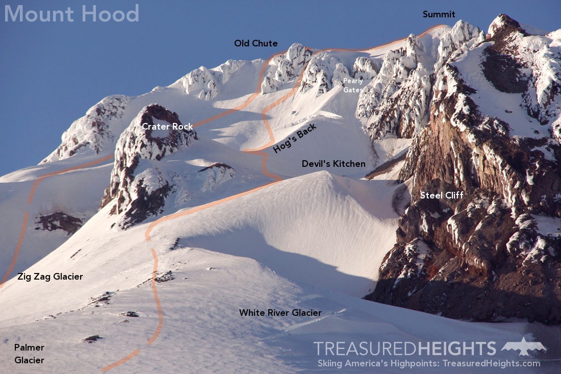
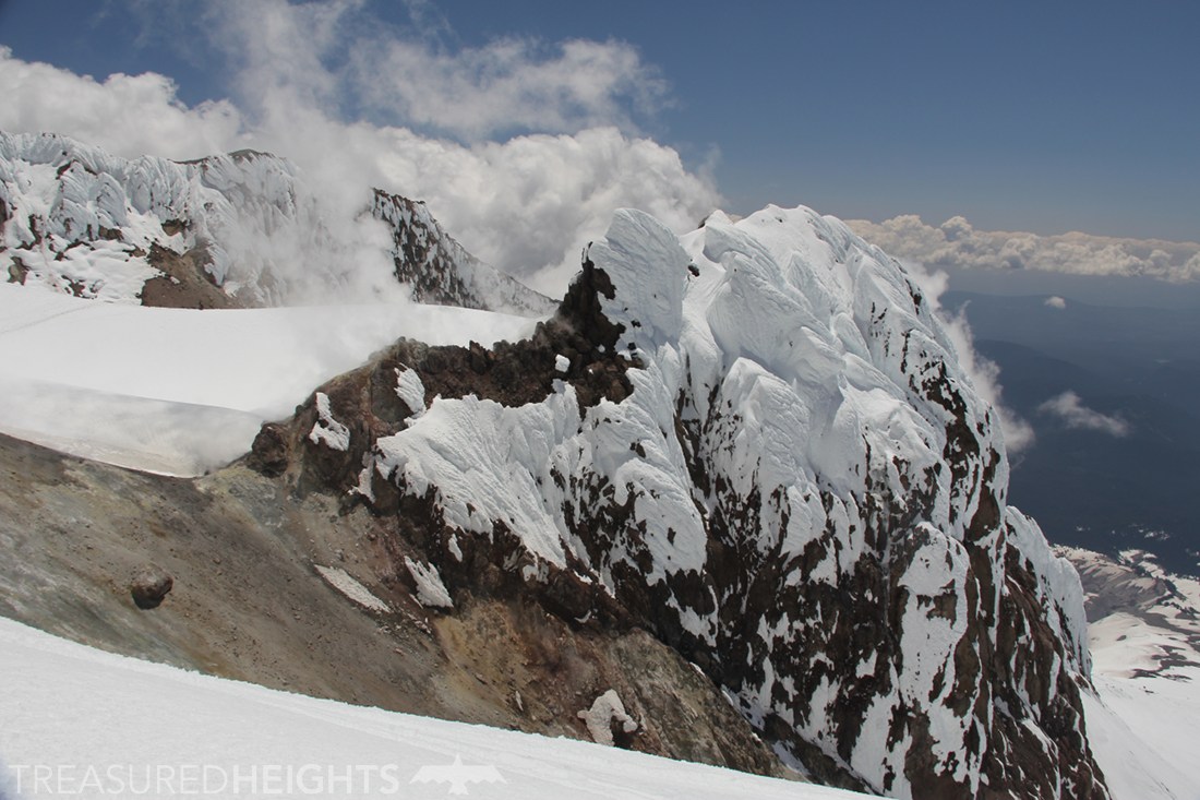
Anxiety and the urge to puke mark this part of the trip for me. An invisible river of CO2 and other gases flow out of series of pits called the Devil’s Kitchen and down the path of least resistance.

The flats of Devils Kitchen was a congregation point for groups near the dark steaming holes. I didn’t hang around this spot and kept doing up to the iconic Hog’s Back feature. Hood’s west side on a good weekend day like this is busy, most of the people here were in snowshoes or crampons, a few skiers ripped here and left for a still-icy run down.
The Hog’s Back
I noticed about half the skiers and splitboarders on the mountain preferred to start their descent from the Devils Kitchen. Another 30% turned around at the Hog’s Back. The Hog’s Back is a ridge of deep snow that sits smack in the middle of the caldera. Mount Hood is not a typical volcano with a round caldera. It’s open on one side, so you don’t recognize the Hog’s Back as a caldera.
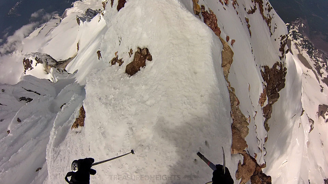
The Hog’s Back is a natural spot for prepping for the summit push there is no doubt you are in a volcano. To the north the slope drops to bare steaming colored hot rock. The Devil’s Kitchen on the other side is glacial snow and ice pock-marked by hot dark pits.
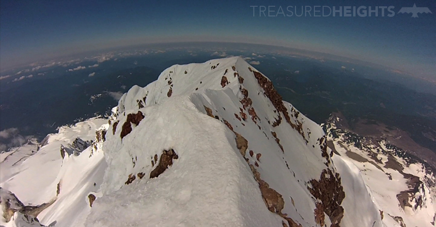
When you’re at the Hog’s Back a massive wall of ice, snow and rock towers rises 1200’ above you to the east. I was surprised to see steam and gases spewing out of towers in the wall, almost like chimneys. The scene is really cool and I’ve never seen anything like it in any other state high point.
Hood’s awesome summit:
I joined the other ants creeping up the shaded slopes of the upper slopes. The route of least resistance here depends on that week’s conditions. The classic way up the peak is via the beautiful rime covered Pearly Gates straight up to the summit. A deep, dark bergschrund can cut off this route. That day I followed the train up the left towards the Old Chute. I’d hardly slept in 3 days so I think that triggered my altitude sickness which peaked here.
After the uneven icy staircase I popped out on the summit ridge. This ridge is really memorable as it varies from 2’ to 10’ wide and is the access point for skiing the Old Chute and other routes that top out on it. I lay in the sun on the glassy rime covered summit. Thick clouds raced over the ridge without warning and then would open up again, giving clear views for 100 miles. Mount Jefferson, Rainier, Mount St. Helens and Mt. Adams were all clearly visible.
Pits of toxic gas:
On Hood there are about 40 rescues every year. Falls and hypothermia are the main causes of death on Mt. Hood, and most of those falls occur in the final slopes above the Hog’s Back. The month before I skied Hood a New Jersey man fell 2000’ off the summit ridge onto the east side. A week before I was there a guy fell down the final caldera slope into a hot hell-hole. He made it out alive with the help of other climbers. Skiing here carries the risk of falling into toxic pits of sulfur dioxide. If you’re uncertain feel free to turn around at the Hog’s Back and wait for ideal conditions to tackle the final slopes.
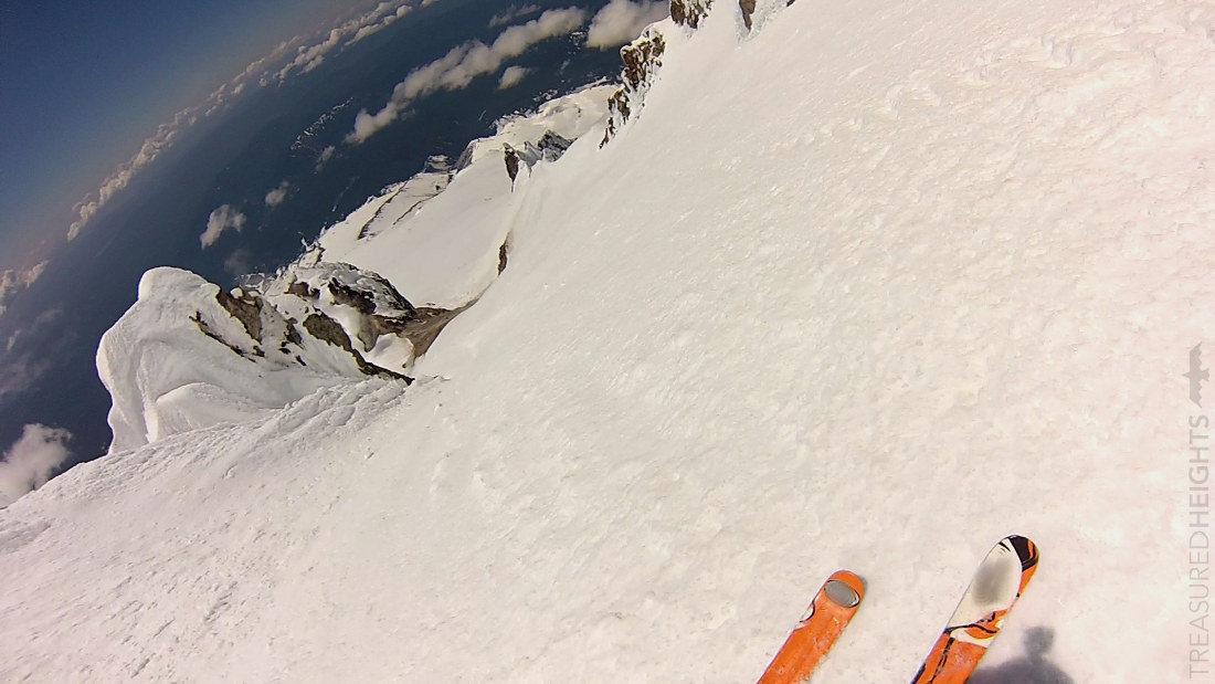
Skiing the Zig Zag:
Skiing the top steep section by the Old Chute was sorta nasty with the icy ridges. That led to some East Coast type crusts. It’s important not to fall here as the slide will take you over 1000’ to the hot rocks.
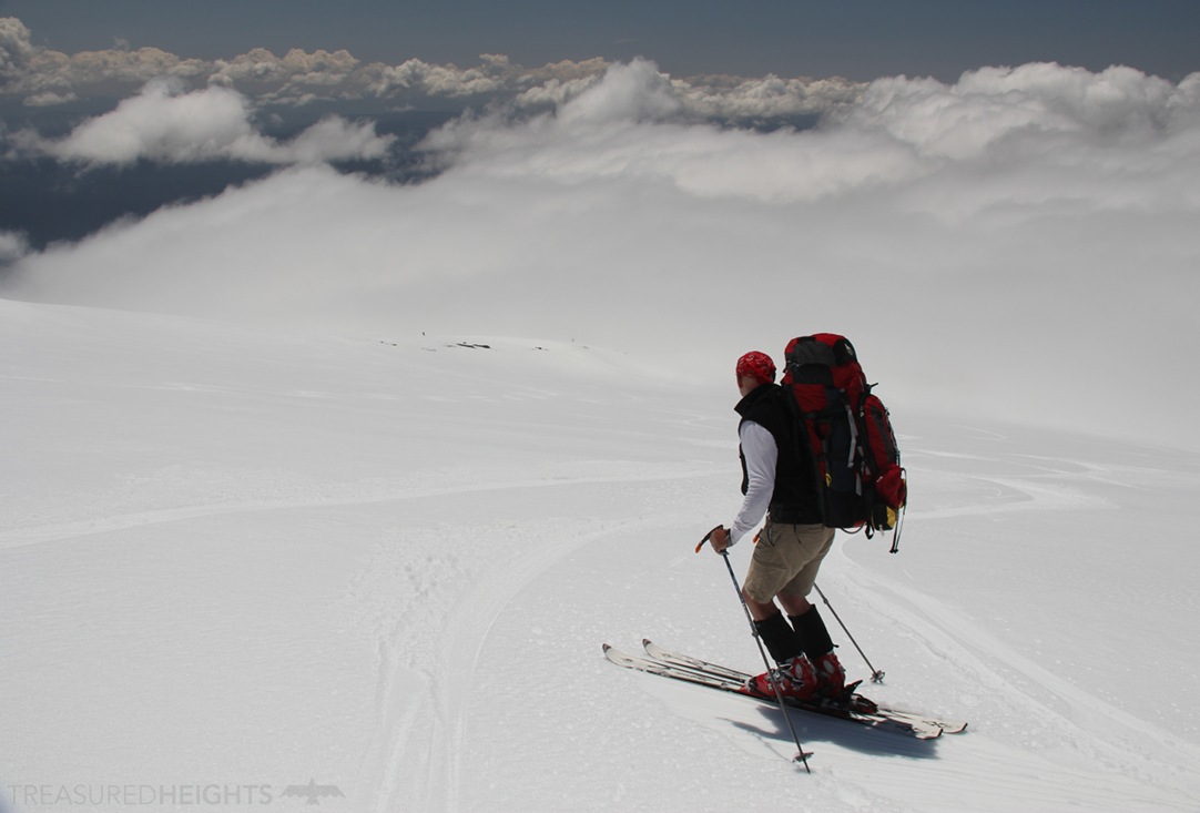
This is another spot where whippets are smart to have along. After a few hundred feet the snow became awesome. I sliced perfect turns down corn snow. A rollover led to the best skiing on the wide steep wall of the north side of the caldera. The apron below (Zig Zag Glacier) was easy and a simple glide to Timberline Lodge.
While packing up my stuff I thought of how close I was to the ocean. I had never skied a peak and been to the ocean in the same day. I drove to Ecola State Park and stood on the beach. From glacial summit to the sea, it was a unique day.
TIPS:
In summer ignore the masses of inexperienced climbers who start too late, you should start your day early. The crumbly lava rock and rime ice begins to fall once the stronger sun hits it. The debris falls directly onto the climbing/skiing routes.
Gear: Have an ice axe, crampons and in my opinion a whippet for the steep final ice staircase. Some people will want to do this roped up. Have other standard mountaineering gear for glacier travel.
Season: April-July has the best conditions for skiing when it’s both warm and has good coverage.
Icy slopes and bulletproof crusts can shut down skiing here anytime, be prepared to bail and ski safer slopes if it’s looking like you can’t get an edge. Chicken heads and other ugly rime formations can be present at the top.
Always have a map, conditions here can change from great visibility to pea soup in just minutes. The popular west side routes seem straight forward but things can get confusing if you shoot the wrong trajectory. You want to keep away from the caldera walls as they have frequent rockfall, minimize your exposure to just the final section.
MOUNTAIN FACTS:
Names: Mount Hood, (Wy’east – Native American Name)
Skiing difficulty: South Side Route: D10 (extreme) If you ski from the Hog’s Back you can drop this down to a double black diamond equivalent
Land: Mount Hood National Forest. Timberline Lodge is publicly owned and privately managed.
Range: Cascade Range
Elevation: 11,250′ (3429 m)
Vertical: 5300’’ (Timberline Lodge parking lot)
Conservation issues: According to some the National Forest Service built too many access roads in the surrounding area over the years and they are having trouble maintaining them. ATV use is in the process of being concentrated in some areas.
Original owners: Upper Chinook and Mollalan tribes
AVY RESOURCES:
Due to the Pacific Northwest snowpack there are very few deaths from avalanches on Mount Hood. However there is a history of some terrifying incidents of avalanches sweeping climbers onto hot volcanic rocks. At 5000’+ of vert on this peak its high enough to have very different conditions on the same route at the same time.
Local avalanche forecasts: https://www.nwac.us/avalanche-forecast/current/mt-hood/
VIDEOS:
Here is a 4 minute video of the condensed ascent and descent:
Mountain Project: South Side Route >
https://www.timberlinelodge.com/
https://www.nbcnews.com/news/us-news/oregon-climber-survives-fall-toxic-mt-hood-gas-hole-n115751
https://en.wikipedia.org/wiki/Mount_Hood_climbing_accidents
http://www.usgennet.org/usa/or/county/clackamas/
https://www.whisperingwoods.net/about/faq/how-did-mt-hood-get-its-name/
More Articles from Treasured Heights:
Skiing in Oregon’s Elkhorn Mountains >
 Get weekly photos on your feed from Treasured Heights from around the US on Facebook or , Instagram.