
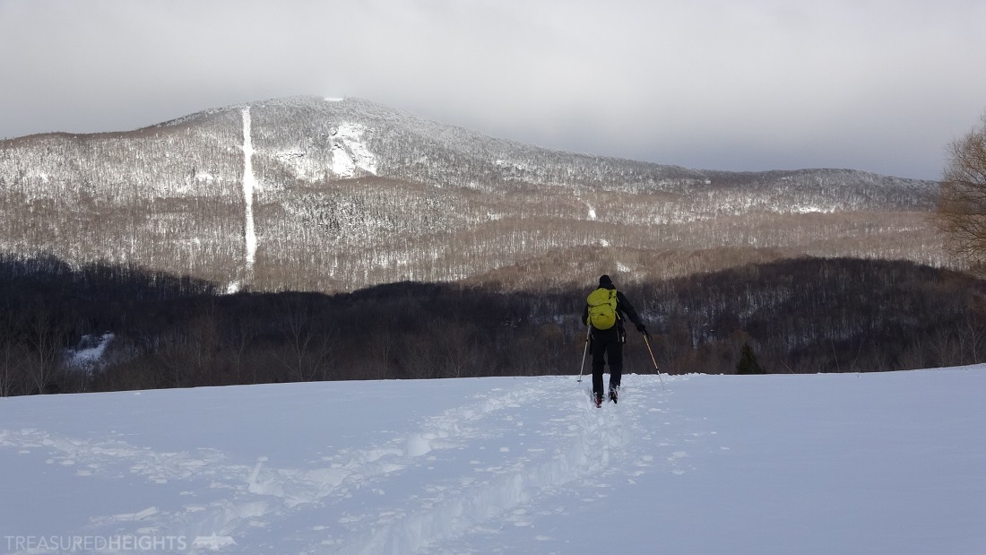
It was a thrilling fast ride following locals on the twisting Thunderbolt Ski Trail on a sunny April afternoon in 2001, and 17 years later I no longer have to jump the stream.
The historic Thunderbolt Ski Trail had only recently been rebuilt in the late 90s and in April 2001 it was a fantastic year for deep late season snow. Now in 2018 I find myself coming back to ski it again. This time they had put a bridge over the stream, and there are ten times the number of skiers. I guess you could say that human-powered skiing is getting closer to returning to its 1930 roots in terms of popularity.
The beauty of the Berkshires have captivated nationally known artists and composers like Norman Rockwell, James Taylor (a local) and John Williams (Star Wars). A road up Mount Greylock and 250 year-old towns nestled in the hardwood-covered peaks make the range very accessible to all. Nearby Tanglewood and Williamstown have brought in some of the nation’s elite for entertainment and college. The beauty and nature of the region even attracted Pittburgh’s George Westinghouse (the AC power pioneer) to build a summer home near Pittsfield. The area in winter sees a fraction of the summer visitors, and when the snow is deep there is potential for both steep skiing and mellow trail skiing.
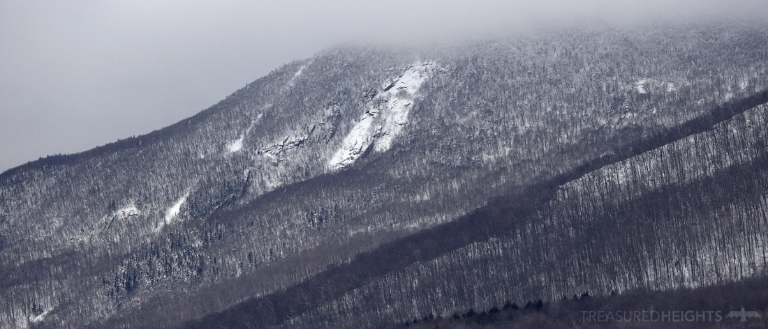
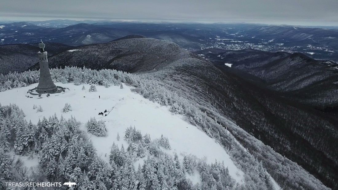
Massachusetts highest point is among two north-south mountain ranges on the western edge of the state. The linear Taconics form a 2000’ wall separating New York from Massachusetts. The Taconics host popular sidecountry skiing at Petersburg Pass where an abandoned ski area sees plenty of action after storms. Mount Greylock stands clearly as the highest peak of the Berkshires just to the east. Greylock is 2600 vertical feet above the historic town of Adams. While the area is not as wild as the Green Mountains or Adirondacks it has beautiful wooded small valleys which have been preserved.
The Thunderbolt Ski Trail:
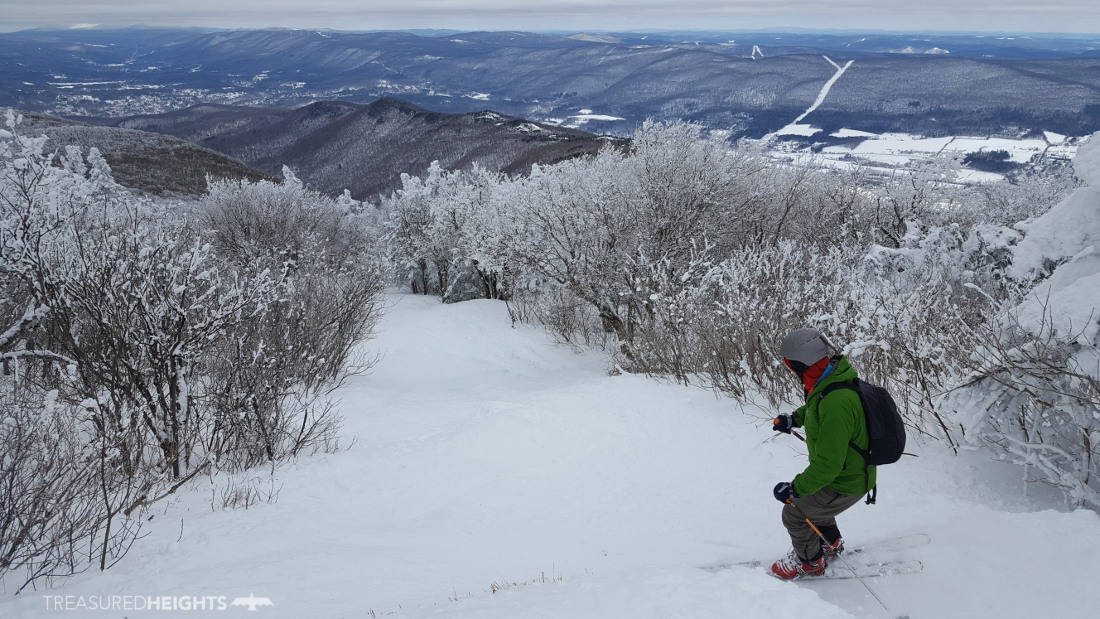
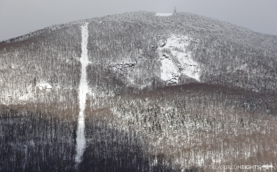
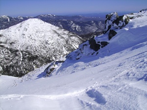
The Thunderbolt Ski Trail goes from the summit of Mt. Greylock down the northern ridge and drops off the east face, ending up at the rural roads above Adams, MA. The ridge section has a view and features cool twisted and stunted birches. The trail then splits as the skin-track trail goes to the left, and the downhill path goes right. It drops as steep as a typical double black in wide open sections and has some gladed sections on the sides. After crossing a stream (now with a fat bridge) the trail has lower angle skiing through the Bumps section. Towards the bottom the trail splits with parts leading to both Theil and Gould Roads. Remember where you parked.
The signage is not overly clear so many people do the uphill wrong. You don’t skin, hike or snowshoe up the downhill trail, there is an alternate trail at the Bellows Pipe intersection and the up trail follows the downhill trail only a few hundred feet to the north.
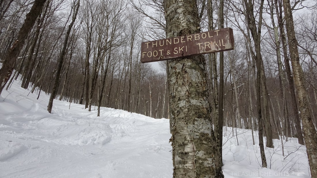
Do not boot up the downhill trail, a lot of people do it and it puts post holes in the middle of the trail which make the skiing suck and it’s dangerous. In many cases skiers without touring gear or snowshoes are the culprits, but in other cases it’s hikers/runners who don’t belong on the ski trail anyway. More clear signage at the intersections would clear up this problem for the most part as most people do it because they don’t know there is a better way up. Spread the word if you see it happening.
Near the top you cross over the road, do this carefully on the up and down as snowmobiles can tear through this fast around the curve, I was almost taken out on the way down by a couple of riders as I popped out of the tight woods onto the road.

The wild sides of Greylock
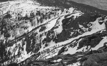
When the snow is good there is more skiing on Greylock. The Powerlines are an obvious fall line route on the east. In between the powerlines and the Thunderbolt Ski Trail is the Indian Head Slide. This is a solid rock slab that can avalanche.
On the western side of Greylock are a number of cirques with steep streambeds that would make great skiing if you have more than 3’ of snow. The Hopper Slide has been skied but like all of the western lines you need a good dumping.
Greylock’s snowfall
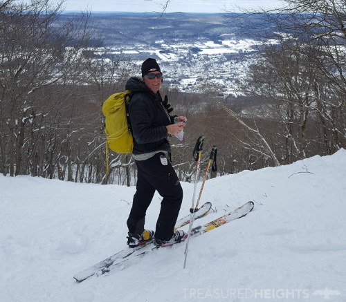
This year I came back to the Northeast with Pat Thompson (tele skier) to film the state highpoints and knock off my last Northeastern highpoint, Mount Katahdin. Greylock was out of the question when we arrived as the snowpack was almost gone after some typical New England rain thaws. I’ve seen and hated these events since the 1990s as they are the most destructive force to a healthy deep snowpack. Dashed hopes were replaced by joy when two noreaster storms dumped over 30 inches of snow on the Berkshires during our travels. We finished the trip with Greylock.

At 3,487 feet Greylock is high enough to have a decent 2k of vertical drop, but not high enough to counteract it’s lower latitude. The cutoff for the Skiing States highpoints project is Connecticut, which is not too much farther south of Greylock and that is for a good reason. Below this the Atlantic States lack a “real” winter with snow that stays for at least 2 months. Pennsylvania and Connecticut only get 20-45 days a year where at least a dusting of snow is present according to national climate data. That dramatically changes to a norm of snow on the ground for the entire winter in northern New York and Vermont. Massachusetts sits in the middle ground and therefore it’s necessary to catch the snow when it’s around.
 Backcountry ski trails are important in changing winters
In backcountry skiing we usually focus on wild lines, gulleys, moose runs, slides and streambeds in the east. Ski trails are limited in number. In the 1930s when the trails were cut there was not the extremely restrictive regulations preventing trimming trees on state forest preserves. The existing non-invasive ski trails cut in the 1930s form an important part of Northeastern backcountry skiing today. In the Adirondacks we have the Wright Peak Ski Trail, the Mount Marcy Ski Trail, as well as The Teardrop and Bruce Trails of Vermont. With winters becoming shorter and snow less predictable we need these trails because trails can be skied on thinner snowpack than off-trail skiing. The Thunderbolt Trail is no exception.
The first backcountry experience
For many the Thunderbolt is their first backcountry experience. The trail is as wide as a resort trail with only a few restrictive points, this attracts new skiers. If you are comfortable with double blacks you should be fine on the Thunderbolt. Hazards which are not found at ski areas will be deep boot holes in the trail and rock bulges which can protrude out on the downside of moguls. The entire mountain is below treeline so bad winds are reduced and this makes a good place to expose first timers to human-powered skiing.
MOUNTAIN FACTS:
Names: Mount Greylock, Grand Hoosuc (18 century English colonial name)
Land: Mount Greylock State Forest Reservation
Range: Berkshires
Elevation: 3487’ (1063m)
Vertical: 2300’
Access: Park on Thiel Road above Adams, or for west side access use the trailhead at 1136 Hopper Road, Williamstown
Conservation issues: Threats to the Berkshires come from real estate developers who are changing the rural nature of the small roads surrounding the peak. Low density real estate development (long driveways into large wooded parcels) permanently ruin chances of public access or future preservation of the mountain area. Since Massachusetts doesn’t have a large mountainous area it’s important it preserve what is left of the Taconics and Berkshires.
Original owners: Mahican (aka Mohican) Tribe
AVY RESOURCES:
Avalanches can occur on Mount Greylock on the Indian Head Slide (east side) and the Hopper Slide (west side). There are no official avalanche forecasts for the Berkshires.
VIDEOS:
 Two videos are currently in production. Subscribe to the TH YouTube Channel to get a notification when new videos are posted. More photos of highpoints like Greylock, Marcy, Rainier, etc. are posted on Instagram throughout the winter.
Below the video of Greylock mixes my 2001 and 2018 descents:
Links:
Official Mt. Greylock State Forest Reservation site: https://www.mass.gov/locations/mount-greylock-state-reservation
History: https://www.skimag.com/adventure/ghosts-thunderbolt
Rando on Mt. Greylock: http://nyskiblog.com/thunderbolt-ski-race-2015/
New Glades: https://www.mass.gov/service-details/greylock-glen-multi-use-trail-system-plan
Mt. Mansfield Ski Trails: http://www.newenglandskihistory.com/cccskitrails/Vermont/mtmansfield.php
The Changing Northeast Climate: https://www.ucsusa.org/sites/default/files/legacy/assets/documents/global_warming/The-Changing-Northeast-Climate.pdf
Other high point articles:
 Stay tuned about new articles and videos by liking the Facebook Page.